South Pike Bay - Passport in Time
Main menu:
Previous Projects > States M-R
South Pike Bay: A Look at Life 8,000 Years Ago in the Mississippi Headwaters
Chippewa National Forest, Minnesota, 1997–1999
by Andrea LeVasseur, FS Archaeologist
From 1997 to 1999, the Chippewa NF conducted PIT projects focusing on archaeological investigations at the South Pike Bay site located on the south shore of Pike Bay in Cass Lake. The purpose of the investigations was to obtain information for evaluating the eligibility of the site for listing in the NRHP.
One of the research questions we asked during our excavation was how the topographic features related to different lake levels as the environment changed through time. The site is situated on two major landforms: a high, wave-cut ridge and a series of lower beach terraces close to the present lake shore. In general, late Paleoindian and early Archaic occupations radiocarbon dated from about 7,400 to 8,500 years ago are situated on the upper wavecut terrace, which probably formed during very high postglacial water levels. Rapid, probably windblown, sediment deposition occurred on the terrace, which is consistent with the dry, prairie-like conditions thought to exist from 4,000 to 8,000 years ago. The lower beach terraces formed after water levels went down, and these landforms were occupied by Initial Woodland and later peoples from about 3,000 years ago to the present. From this study and through comparison to other lakeshore areas, we have better information to use for predicting where new sites will be found and how old they are just by studying where they are located on the landscape.
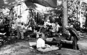 (Photo: PIT volunteers excavate at the South Pike Bay site, Chippewa NF, Minnesota, 1997)
We also tried a rather innovative approach to artifact analysis. For many years, archaeologists have noted apparent changes through time in the use of lithic material types. This has led to the hypothesis that certain lithic material profiles appear during specific cultural periods. A profile is a description of lithic source materials characteristic of certain time periods. For example, an Archaic-period profile may have a lot of chert and very little quartz, while a Woodland-period profile is sparse in chert but has abundant quartz. These profiles may reflect differential exposure of material sources at different times in the past, the proximity of sources to human settlements or activity areas, or simply cultural preferences for certain materials. If profiles could be tied to time periods, the relative abundance of certain types of rock could help in identifying how old the site is, even when there are no other clues.
At South Pike Bay, we tried to develop these lithic profiles by quantifying the various material types found for each time period. There are very few profiles developed for other sites in the Mississippi Headwaters area, so the South Pike Bay data will be very useful as comparative data for future studies.
Many tools, other artifacts, faunal remains, and archaeological features were found on the upper terrace. Twenty projectile points, including Agate Basin, Durst Stemmed, Parkdale Eared/Oxbow, and HiLo, were recovered. Woodland ceramics were poorly represented, but included Brainerd, Blackduck, and Sandy Lake wares. At least 10 archaeological features were found. Nine of these appeared to represent work areas where people made and modified their stone tools, whereas one may have been a deposit of discarded cooking or heating stones. Animals identified from tiny bits of bone include deer, bear, and turtle, with small mammals, fish, birds, and mollusks present in small amounts. A significant concentration of bone in one area may represent a foodwaste disposal area. Burned bear paw fragments suggest that rituals possibly took place at the site (burned bear paw bones have been associated with the spiritual rituals of later peoples).
About 75 volunteers braved the heat, poison ivy, flying predators, and skunks to participate in excavation and laboratory identification of what was found. Thanks to the volunteers’ efforts, the site was found to be NRHP eligible, and the forest can now focus on managing the campground to enhance the preservation of its archaeological values.